Route planning for bike touring has always been one the necessary evils that we secretly love. But in current times there is a contender to the almighty paper map.
Bike Travelers Have Traditionally Used Paper Maps
For a long time travelers have relied on paper maps for:
- Route planning for the coming days on a bike tour
- Working out where they are and check when to make turns.
- Spreading out on the table to see “the big picture” and to discuss that with each other.
- Marking up proposed and taken routes with highlighters
In recent years, digital maps on laptops and smartphones have relegated paper maps more to the status of souvenirs. When it comes to actual navigation there is simply no comparison between digital and paper maps anymore. It is often nice to have a big paper map but is not the best thing to rely upon.
Advantages of Digital Mapping & Navigation for Route Planning
- Free or virtually free, take up no space and add no weight.
- Easy to get, compared to what was often a time-consuming process of finding maps, particularly when you were not in the country or region concerned.
- Highly detailed (every street in every city and town) and global. Zoom in and out. Terrain. Ride
profile information. Camping and hotels. Public transport. - Precise routes that can be easily plotted and then overlaid above the screen map.
- The navigation device has a GPS locator button which, in a few seconds, shows a dot that indicates your current location on the map.
Disadvantages of Reliance on Digital Maps for Route Planning
- The device can be broken, stolen or lost and is affected by high temperatures (turns itself off)
- Occasional access to the internet is needed in order to upload new routes or “tracks”.
The core advantage of digital is in the integration of the level of location accuracy with the fine detail in the maps, plus being able to overlay a separately plotted route. Taken together, these tools stop you wasting time and getting lost. They allow you to find and take better routes, away from traffic, that are more scenic and safer.
Countless examples could demonstrate this. Below we present a random one from a 2015 Vivente World Randonneur test ride. If you are already using digital mapping you’ll already know about this. The day’s route, in Belgium, was plotted the night before using google maps on a small laptop. The route was transferred to a navigation device for use during the day.
This was a Samsung (android) Galaxy S5 smartphone with an OSM app. At the end of the day, in Brugge, Belgium, we purchased a quite detailed (1:150,000 or 1cm=1.5km) paper map just to be able to compare the detail of the map with the detail of the plotted (and just ridden) route.
It was a wonderful ride, largely on narrow, quiet, sealed country lanes with farms close on both sides. This type of route is superior to riding on the normal roads although in Belgium they are also very safe. Bike tourers and Bike Packers like being outside surrounded by nature. So the closer to the country, the animals, and the farming, the better.
Looking at the paper map that night we searched for an area of these country lanes through which the google map-generated route had taken us. We wondered, if we had only had the paper map, would we have found these particular routes?
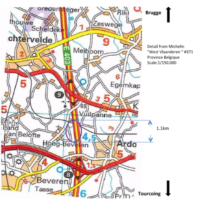
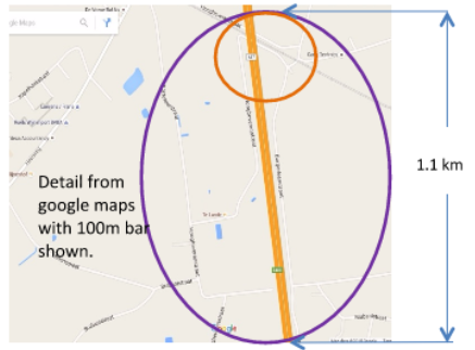
At first it was like looking at a map of a different region. Eventually though the area circled in purple in the map section above was determined to be the same area as shown below on google maps below.
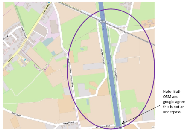
OSM, below, has a different look to google maps but the roads and lanes are in the same places. It is this OSM map that we saw on the screen during the day and the route in blue (above) was superimposed on the OSM map below.
On the digital maps you can zoom out to a scale similar to that on the Michelin map (1:150,000). Sometimes it’s good to do that to see where you are in relation to the whole days’ route, or a city, bridge or other feature. But when in densely settled areas with many small lanes you want to zoom right in to a level that is impossible on a paper map.
For a paper map of this area to have the detail needed to show the roads we took in that area, it would need to have a scale of about 1:25,000 or six times the resolution of the one we bought. To get the detail of the backroads, at least in densely settled areas, the map needs to be so high-resolution that you are buying and dumping maps every day. At 1:25,000 you’d have a 4 meter wide map just to cover a single 100km day. It would be a shame to be denied superior routes, particularly when they may be just a hundred meters away and more enjoyable, just because you have a paper map that does not show them.
None of this is to deny the pleasure we all find in studying a large paper map. We are not suggesting the paper map has no place in the kit. But, in actual day to day navigation, digital now provides a level that paper does not offer. And digital is readily available. You probably don’t even need to buy anything.
Cyclists are picking up on this fast and a whole world of route planning and plotting tools and mapping applications is thriving.
Some of Our Trips
-
Drop bars in the real Balkans
This corner of Europe has come to our attention recently through the development and promotion of the Trans Dinarica Cycle Route. But for a long time the region seemed intriguing, if not a bit impenetrable. Back in the early 1960s, after Dervla Murphy rode through what was then Yugoslavia on her way to India, she…
-
The Gentle Gradient: Uncovering Victoria’s Gippsland Rail Trails
In Australia, Victoria has a strong history of cycle advocacy. Over the decades, the state has accumulated extensive bicycle infrastructure.
-
Exploring Maharashtra, the 2,000-year-old Ajanta Architecture and the Ellora Caves
A ride on the Deccan plateau, from Nagpur to Hyderabad via the Ajanta and Ellora Caves. We chose the Swabia model, with 40mm Goodyear tyres and 50:19 Rohloff gearing.
-
Four Rivers, East Coast and Seoul
South Korea has become a cycling favourite for many, so we decided to explore its appeal. After covering 1,300 km, we’re now enthusiasts ourselves and are already planning a return trip.